Weatherwise, January 2014 was a remarkable month with several records falling, and precipitation being recorded on every day of the month. It was the mildest, wettest and windiest January recorded so far at Bracken House.
The incessant rain was the main feature of the month with a total of 90.4 millimetres being recorded. This was 46.7 millimetres more than the January average of 43.7 millimetres. For the first time, precipitation, a combination of rain, snow melt, frost melt and fog, was recorded every day, with the wettest day being the 31st, when 9.6 millimetres was recorded. Evapotranspiration for the month was 12.1 millimetres, higher than the 11.3 millimetres of 2013.
January was also the mildest ever recorded here, with the average for the month being 5.0°C, a mere 0.1°C milder that January 2012. The highest temperature recorded was 11.3°C on the 5th, amazingly at 23:59. The minimum temperature was -1.2°C on the 21st at 09:10, the highest monthly minimum for January and the second lowest temperature this winter, beaten only by the -2.3°C recorded on November 19th 2013. The mean temperature for January is now 3.5°C. There were only three frost days, when the temperature falls below zero, on the 12th, 20th and 21st. This is also a record for the lowest number of frost days in January. Despite all the rainfall, there was 58.5 hours of sunshine in the month, 6.4 hours more than 2013. The average dew point was 3.7°C and the maximum heat index was 11.3°C at 23:59 on the 5th. The average daily maximum temperature was 7.7°C and the average daily minimum was 2.4°C.
In the early hours of the 12th, the temperature dipped below 0°C, this was the first time an air frost has been recorded since November 26th 2013. The spell of 46 days without any sub-zero temperatures is easily the longest spell recorded in the Winter period. The previous best period of above zero Winter temperatures was one of 26 days, between December 15th 2012 and January 9th 2013. On the 30th, the maximum temperature of 3.9°C, recorded at 22:08, was the lowest daily maximum since March 28th 2013.
The last day of the month saw the first measurable snowfall of the winter when 0.2 millimetres was recorded. Snow, sleet and rain fell throughout the day, but only settled in two brief spells in the morning and late afternoon.
The month was also a very windy one, with the strongest gust ever recorded in January of 43.7 mph from 293° (WNW) at 14:27 on the 25th. This was during a fierce thunderstorm, uncommon in these parts in January. The maximum wind speed was 26.5 mph from 293° (WNW) on the 25th at 14:28. The average wind speed for the month was 6.0 mph, the same as in 2012, but the maximum average daily wind speed was 23.7 mph, a high for January. The average gust speed was 9.2 mph, also a January record. The total wind run was 4452 miles, also a January record, but lower than December’s 4565 miles.
The average barometric pressure was 998.1 millibars, a January low. The highest pressure recorded was 1023.2 millibars on the 11th at 22:06, and the lowest was 978.3 millibars on the 1st at 19:35, another station record.
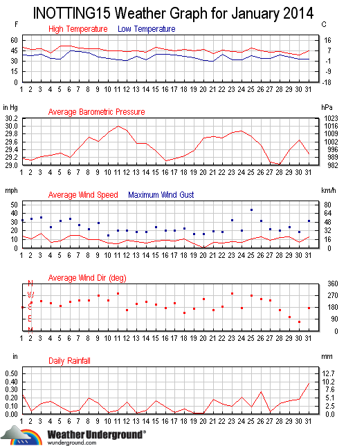
Weather Underground graph for January 2014.
Related articles
- Weather review – December 2013 (alanrowley.info)
- Squall line causes dramatic weather changes (alanrowley.info)
- Record frost-free spell ends (alanrowley.info)
- January 2014 – very mild but no record breaker… (xmetman.wordpress.com)
