2014 was the joint warmest year so far recorded at Bracken House. The average temperature of 10.3°C equalled that of 2011. Every month recorded above average temperatures, except for August whose average of 14.2°C was the coldest August recorded here, and a full 1.0°C below the monthly mean. The highest temperature recorded was 27.6°C on the 26th July, with the coldest being -3.1°C on December 30th. The average high temperature was 14.1°C, equalling 2011’s best, with the average low temperature being 7.0°C, the highest for this location. The yearly mean temperature is now 9.4°C.
The above You Tube video shows the whole of 2014 in 4 minutes and 20 seconds. The time-lapse was recorded by the Bracken House webcam. There are a few bad frames caused by re-positioning of the camera and camera freeze.
In 2014, there were 549.6 millimetres of precipitation, well below the high of 826.8 millimetres set in 2012. Six months recorded above average rainfall, and six months below average. The average yearly rainfall here is now 559.3 millimetres. Precipitation was recorded on 222 days, with the wettest day being July 19th, when 21.6 millimetres of rain fell. Rain was recorded on the first 33 days of the year, with February 3rd being the first completely dry day. The first significant snowfall was on December 26th / 27th, when 9.0 centimetres fell. A light dusting of snow fell on December 11th, settling on the grass, but very quickly turned to rain.
Winds were normal throughout the year, with the average being 4.2 mph. The highest recorded gust was 47.1 mph, set on February 12th, equalling the station record. The year’s wind run was 37,142 miles, with the predominant wind direction being west-south-west.
The average barometric pressure was 1010.6 millibars, slightly lower than the mean of 1012.8 millibars.
Sunshine hours totalled 994.3, 9.3 hours down on 2013’s 1003.6 hours. The maximum UV index was 7.3, compared to 2013’s 7.7.
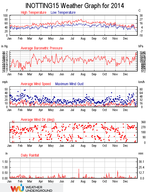
Weather Underground graph for 2014.